Tuesday, November 29, 2016

A Non-Traditonal Thanksgiving


Sunrise in Joshua Tree

For my entire 56 years on this beautiful planet, Thanksgiving has always meant one thing - celebrating with friends and family gathered around the table laden with the traditional turkey, stuffing, cranberry sauce, pumpkin pies, and other delectable dishes.  It has always been one of my favorite holidays, embodying all that is best about love, family, and friendship, without all the commercial excess that accompanies the next big holiday on the calendar.  I also like it for it's simple theme.  There is so much pain and suffering in the world today, and we are all fortunate to have so many things to be thankful for, many of which we take for granted on a daily basis.  It is good to stop and reflect on how truly blessed we are.

We have friends who have a somewhat different twist on the Thanksgiving tradition.  They still observe the true meaning of the holiday, but they choose to do it camped in the beautiful surroundings of Joshua Tree National Park.  They have invited us to join them several times in the past, but the pull of tradition is strong, and I, especially, found it difficult to change.  This year, however, with a lot of our family making other plans, seemed like the prefect opportunity to explore this alternative celebration.

We decided to take the entire week off, and began with a visit with Ryan, Jacque and Joss.  Always a treat to see this little bundle of energy

Joss excited to play in some puddles, a rare event her her short lifetime.
In order to get in the proper frame of mind to deal with LA traffic, we stopped at Mt. Pinos on the way down, camping alongside a nondescript dirt road near the base.  The wind was howling, but we were nice and cozy ensconsed in the van.  Saturday morning we rode up the trail to the nordic center, the 8,000' elevation challenging our hearts and lungs. 


The November chill was perfect for riding uphill, and there were very few others on the trail.  After a rollicking high speed descent we were ready for whatever lay ahead on the freeways. 

We drove to the Beachwood Blendery in Long Beach, where Ryan was having a new bottle release, and sampled a few of his award winning beers.  The next day we were able to visit with Jacque's Mom, Mary, who is in the hospital courageously battling through complications arising from her recent bone marrow transplant.  Her husband Ron was there as well, as he is every single day, helping her get through this trying time.  Again, so many things to be thankful for.

Monday morning we said goodbye to Ryan and Jacque as he headed off to work, and we pointed the van towards Deep Creek hotsprings, nestled in the San Bernadino mountains outside of Hesperia.  This hot spring has been on our wish list for many years, but we seldom find ourselves in this neck of the woods.  But since it was basically right on the way to Joshua Tree, it seemed like the perfect time to check it out.

We camped at the private Bowen Ranch, right where the trail to the hot springs begins

The springs are alongside the banks of Deep Creek, a 2 mile hike and 900' descent from camp.  The river corridor provides a striking thread of color through the dry desert landscape.
It was still chilly and windy when we arrived in the middle of the day, but as we descended into the canyon the wind was blocked and the temperatures rose.  The springs were wonderful, and there were only a few other friendly people sharing them.  It can get quite crowded on the weekends, so we were happy to be able to experience them on a mellow weekday.  No pictures of the hot springs, unfortunately, as our cameras were off with our clothes somewhere on the banks, and we never made the effort to retrieve them.  Suffice it to say that it is a very picturesque locale, and very much worth the hike in and out.

Tuesday morning dawned clear and cold, with a blanket of frost surrounding our campsite.  The distant peaks were covered with a dusting of snow from the previous days storm.  After some yoga and stretching in the morning sun, followed by a hearty breakfast, we set out to explore the area on our mountain bikes.  The US Forest Service land here is crisscrossed by a network of 4WD and motorcycle trails, so we were confident we could find something fun to ride and get some exercise too.
Snow covered Mt. Baldy in the distance


Most of the riding was on dirt roads, but they were steep and fun.

A lot of the motorcycle trails went straight up and down the gulleys.  While they made for some fun descents...

They were often too loose and too steep to ride up, so we had a little hike-a-bike as well.
We did find a few sections of the moto trails that wound through the various drainages and were lots of fun to ride.  After working our way back to camp, it was on to Joshua Tree.  We arrived about 4:30, found our friends, and set up camp for the next few days.

Our friends Steve and Shannon, and Robb and Alex, have been coming to Joshusa Tree with some of their friends for Thanksgiving for 15+ years.  A tradition that started with childless couples now includes many kids from kindergarten through high school age.  Donette and I were the only couple without any of our offspring along. 

Donette and I both used to rock climb a fair amount, but over the years that sport has kind of fallen by the wayside.  Don't worry said Steve,  the climbing would be kid focused, and therefore "easy".  Not that it actually worked out that way.  For one thing, the older kids are darn good climbers, and the adults are also all good climbers who want to challenge themselves.  As a result, there was a dearth of "easy" climbs set up, and we got to jump right back into it.

Needless to say, an 8 year hiatus from rock climbing did little to improve our strength, stamina, or technique.  But we managed to thrash our way up most of the climbs, and it was a ton of fun.

Our group occupied this nice little cove in the rocks

Shannon teaching Rowan to belay


Jessa works her way up the rock

We all know it's a good idea to keep the kids well fed, so Robb set up a rope close to the table

Steve climbs one of the routes right in our camp
Solar powered Luci® lights illuminate our bounty

Part of the gang gathered around the campfire


Thanksgiving dinner was a potluck affair, with Charlie and Mandy cooking up the main course, some perfectly grilled tri-tip, quite an accomplishment on the rudimentary campground grills.  Prior to beginning our feast we all circled around the campfire and shared the things we were thankful for.  Some of the children spoke about how this was how they had spent every Thanksgiving during their lifetimes, and how it was the highlight of their year. For us it may have been a non-traditional setting, but the heartfelt sentiments and thankfulness expressed by ever single person present was as traditional and heartwarming as any Thanksgiving can be.

Monday, November 14, 2016

Post Election Reflection


Like many of you, I woke up the morning of Wednesday, November 9, feeling a little stunned.  Shocked.  Baffled. Nervous about the future.  After months of contentious election coverage, I wasn't really in the mood for more continuous negativity, which pretty much surrounds us nowadays.  The solution, load up the van and head for the mountains.  Donette was in Portland for a little mother-daughter time, so it was just Luna and I.

Now, where to go?  With only a 3 day weekend, I didn't want to set my sights too far.  With some brand new tires on the van, I searched out some off-highway choices.  I came across Dove Springs Canyon road, which traverses the mountains south of Weldon and ends up at the Jawbone Canyon OHV area.  It didn't look too difficult, a plus since I was traveling alone.  I left late Thursday evening, spent the night near the Kern River at Lake Isabella, and headed for the trailhead Friday morning.

The Lake Isabella area had been hit hard by wildfires this year, and there were large areas of devastation.  Many homes remained intact with the surrounding areas burned.

Burned Joshua forest
Badly burned tree
This property wasn't so lucky, with a pile of charred treasures

Not sure what business is being transacted out here.
The trailhead was well marked, and the road was pretty smooth, although quite sandy in places.  Since it was down in the bottom of the canyon, I took the opportunity to climb a nearby ridge, hiking up about 900' above the road to get some exercise and better views.  It was dead calm, and incredibly quiet.  Only the occasional birdsong broke the absolute silence.  Ahhh!


Airing down the tires to start the dirt section

Trailhead was well marked and easy to find

Nice, smooth sandy road, for the most part

The road gradually climbs to the low saddle in the middle of the picture

After hiking back to the van and resuming the drive, I did start to see a few fellow off-roaders, usually on motorcycles.  However, in 20 miles I only saw 4 groups, so not very crowded at all.  At the top of the pass, about 5,200, the road crosses the Pacific Crest Trail.  There is a nice pullout there with a picnic table, so it made a good rest stop.  I pulled out the bike and, resisting the urge to ride the PCT, rode up a side road instead.  It was steep and sandy, making it quite challenging.  After a little out and back I returned to the van to find a group of three motorcyclists.  They were a little surprised to see me ride up on a mountian bike!

The PCT heading off into the desert hills

One big pipeline headed to LA on the Eastern side near Jawbone Canyon

After completing the drive, I headed up 395 to Lone Pine.  My goal was to camp at the end of a dirt road that heads up to the Tuttle Creek trailhead.  I had been there once before, in the late spring, to attempt a ski descent of Mt. Langley.  That turned out to be an extremely challenging adventure, and this time I was on a more relaxed pace to just spend some time in the mountains.  The road was in pretty good shape until 1 mile from the end.  Someone had gotten stuck there and chewed up the road in a narrow, rocky section.  I made one attempt to get past, but with the van teetering on three wheels as it tried to climb over the rocks and thru the holes, I decided not to push it and backed down to a nice large campsite at about 6,600', with expansive views of the Owens Valley.  That night we were treated to another calm evening and a beautiful moonrise.

End of the road at Tuttle Creek


Saturday I hiked up the trail to the old stone ashram, nestled in the woods at about 8,000'.  It brought back memories of Nepal, thinking about all the labor to build a stone and wood house miles from the end of the road.  There were gorgeous views outside each window, and surprisingly little vandalism or graffiti.  The morning sun was just hitting the bottom of the canyon as I arrived,  so I spent some time there stretching and soaking up the warmth.  I then followed a slight use trail higher up the drainage.  The last time I was here this area was covered in weak, crumbling snow, and we continuously punched thru the barely covered brush.  Skis on or skis off, it was a sufferfest of a climb.  This time was much easier, as it was relatively easy to find a clear path thru the shrubbery and up the steep slope. 

Tuttle Creek trail, Mount Langely in the distance

The Ashram

Great views from every window

You can barely see it when approaching from above


After about 3 hours of hiking I had covered about 4 miles and gained over 3,000' of elevation.  I decided that was plenty for the day.  After a snack I retraced my steps, and encountered a few fellow hikers making their way to the ashram.  It appears to be a somewhat popular hike, but judging from the faintness of the trail above the ashram, it also seems like most people turn around there.

Back at the van I loaded up and descended to explore the Alabama Hills.  I have driven past them many times, but never really got off the main road to look around.  It was a very popular destination this weekend, and every nook and cranny was filled with climbers, campers, motorcyclists, and day hikers.  I drove further and further out on the main road, looking for an uncrowded spot. I cam across a side road with signage saying not suitable for cars or pick-ups, but 4x4's only.  Sounds promising!  It turned out to be easily passable by almost any car, but hey, if the sign kept the crowds down that was great.  I found a nice cozy campsite with two low rocks guarding the entry.  The van would just barely squeeze between them - perfect!


I pulled out the bike to do a little exploring, and came across a singletrack trail cutting right thru the middle of the Hills.  It was pretty loose and sandy, and made for tough riding. I did get to enjoy the beautiful golden glow of sunset at 3:30 in the afternoon.  The sun disappears early when there is a 14,000 monolith between you and the west.

Evening light in mid afternoon

The real sunset, at the appropriate time
Luna loved the rocks near camp, and excitedly scampered up and down, sniffing out all the caves and crevices filled with rodent poop.  She is quite the climber with her four claw grip, and the rough, textured rock let her ascend virtually vertical faces.
Of course, the first thing you have to do after getting out of the van is roll in the sand to get a complete covering of dust...

Then explore all the little caves and crevices...
Discover that this rock is really grippy...
And stare off into the desert from the highest point around.
While I enjoyed the campfire

Sunday morning I rode the bike a little further up the sandy motorcycle trail, then returned to pack up.  I decided to explore another road I have never traveled, and left 395 and headed up towards Kennedy Meadows and Sherman Pass.  Traffic was virtually nil, and I pretty much had the road to myself as I climbed quickly from the desert floor.  A little past Kennedy Meadows is the Blackrock recreation area.  I  couldn't believe all of the motorcycle and mountain biking trails in this area.  Lot's of dirt roads for access to the trailheads as well.  I sense another trip here in the near future to explore some of these trails and camping areas.

The air quality in the Owens Valley seemed quite good, but as I headed  into the heart of the Southern Sierra it got worse and worse.  I took a side dirt road up to the Bald Mountain Lookout, and the air was hazy with smoke.  I hadn't heard of any recent fires, but something was obviously burning.  Approaching Sherman Pass visibility was down to just a few miles.  On the descent into the Kern River valley, I finally saw the source, and a large fire was burning high up above Johnsondale.
Bald Mountain Lookout

Pano to the south, Domelands barely visible in the haze


The hazy view from Sherman Pass


This drive was not the quickest way to the Eastern Sierra, but it was the quietest.  In the 70+ miles from 395 to Kernville I only saw a dozen cars.  In the future, I would only take this route if I had time to stop and spend the night enroute, as it was much too long in the van for a single day.

After 3 days of peace and quiet it was back to radio, newspapers, and political conversation. It is encouraging to see many people trying to push past the negativity and move forward.  It is equally terrifying to see some of the bigotry and hatred now being openly displayed.  I am confident that our nation will eventually get back on the right path and continue to move forward, but it won't be easy.  In the meantime, it is comforting to know that all it takes is a tank of fuel and a few hours behind the wheel and you can get lost in the majestic beauty of what really makes this country great.


Friday, October 7, 2016

Road trip to Southern Utah

What constitutes a long term friendship?  How about 30+ years? How about even though you may only see each other every few years, when you do get together it's like nothing has changed?  Donette and I are both blessed to have several friendships like this.

Donette has known Kaj, Teresa, and Sandy since their college days at UCSB.  Kaj and Teresa live in Germany, so we don't get the chance to see them that often.  They were in the Western US for a conference, and had a few extra days to spare.  When they asked if we wanted to meet them in Southern Utah for a few days we said "of course!".  Sandy lives in Sacramento, and wanted to join the party too.  Rather than drive two vehicles out from California, we arranged to pick her up at the airport in Las Vegas on our way by.

We wanted to break up the drive, so we left CA on Friday and headed for the Mojave Preserve near Baker. 


A few miles of rough dirt road led to this Lava Tube. After a few miles of washboard Donette pointed out that we did have the mountain bikes in the back, and it would be just as fast, more comfortable, and more fun to ride the bikes.  We pulled over, unloaded bikes, and road the rest of the way.


Enjoying the desert sunset.

Evening ride through the Mojave  

Saturday morning we got an early start and headed for the Vegas airport.  Approaching the arrivals area, I was remembering our close call at the Portland airport when we almost tried to drive into the parking garage with our kayaks on the roof racks.  One of the first things we did when we got the Sprinter was measure the vertical clearance so we would not find ourselves wondering just what we could squeeze under.  Sure enough, as we came around a curve we saw signs saying 7'6" clearance ahead, much too low for us.  We quickly scooted to a lane shooting off to the right, only to find another sign saying 7' clearance ahead.  Not what we wanted to see.  With only one other option, we scooted even further to the right and were rewarded with a sign saying "Oversize vehicles exit here".  Whew, we were are out of danger, but now Sandy is down there waiting for us.  We found a place to pull over, got her on the phone, and managed to connect before too long.

Our destination this afternoon is Gooseberry Mesa, a few miles outside of Hurricane UT.  It has some fabulous slickrock mountain biking trails, and since it is BLM land we can camp there as well.  We had borrowed a bike for Sandy so we could all enjoy the riding.

Donette on a flat section of the mesa

You can ride as close to the edge as you dare!
Ray riding a roller coaster section
Sandy enjoys the view from the edge

Panorama with Zion NP in the background
That evening we found a beautiful campsite on the edge of the mesa with gorgeous views of Zion NP to the east.

Sunday morning Donette and I got up early and did another ride, while Sandy made up for a lack of sleep the night before.  Then it was off to Virgin, UT to meet Kaj and Teresa.  Not knowing the town of Virgin at all, and wanting to make it easy to find each other, I had Googled the town looking for an easy to find place to meet.  I came up with the Kolob General Store, which according to the online map was just on the eastern edge of town, on the road we wanted to take to the northern edge of Zion Park.  Perfect! I sent the info to Kaj and Teresa before we left, secure in the knowledge we would now easily find each other.  As we drove into Virgin and headed up the Kolob Terrace Road, it soon became obvious that something was amiss.  There was no general store on the outskirts of town, and the road quickly headed out into the wilderness.  We retraced our route back to town and inquired about the whereabouts of the General Store.  Turns out it is indeed on the Kolob Terrace Road, just 24 miles north of town!  With extremely poor cell service, and Kaj and Teresea having German cell phone numbers, we were not having any luck contacting them.  Suddenly a text message popped up that they had indeed gone to the proposed meeting place, but since it was so remote assumed there was some mistake and were headed to Virgin.  A couple of minutes later a call came through, and they were at a neighboring business just a few hundred yards away. Yay, crisis averted.

We drove up the Kolob Terrace Rd into the northern part of Zion NP.  There is no entrance station here, just a cattle guard and barb wire fence to let you know you have crossed into the park.  We stopped at the first trailhead and hiked down into the North Creek drainage.  It was a short but challenging hike.  After returning to the cars, we exited the park and found a dirt track off the main road leading to the edge of the North Creek canyon.  We followed it to the end and found a great campsite, less than 1/4 mile form the road, and only about 20 yds from the NP boundary.  The wind was blowing pretty vigorously, so we used the van and car to create a windbreak for the kitchen. 

The peaks in Northern Zion awash in the evening light

Sunset behind our camp


More views from camp
Monday morning dawned chilly and breezy.  Our first plan was to explore a slot canyon, but the thought of slogging through cold water with air temps in the low 40's and wind chills in the 30's led us to reconsider that plan.  Instead, we opted for a hike out to an overlook in the upper part of the park, the Northgate Peaks trail.  The wind was brisk, but hiking was pleasant. At then end of the trail we were rewarded with some pretty views, but we all felt it had been too brief of a hike, and were looking for a little more adventure.

 This little peaklet was right at the end of the trail, and it looked like it was climbable and would afford even better views from its summit.  It was indeed a fun challenge, and we all reached the top.

Panorama with North Guardian Angel peak in the distance

The gang on top
 As we retraced our route to the car, we passed the intersection to the trail leading to the Subway slot canyon.  Subway is a challenging slot, and it is so popular that there is a lottery to get permits to enter it.  We did not have said permits, and we also did not have the gear or the time to attempt it.  We did, however, have a couple of hours and and a surfeit of energy, so we ignored the "Permits Only" sign and headed down the approach trail to check it out. This turned out to be a wonderful addition to the hike, as we dropped down sandstone slabs into an ever narrowing canyon.  We made it to the point where we could see down into the beginning of the narrow section, and then retreated to the cars.

Not wanting to camp in the cold at the higher elevations, we headed down to the town of Virgin, where there was well developed free camping along the banks of North Creek.  Our trip planning came down to the wire, as we ran out of tequila and wine on this, our last, evening.

Tuesday was departure day, and we had to return Sandy to the Vegas airport by late afternoon.  We decided to get an early start, brave the crowds, and do a hike in the heart of Zion NP.  Luna through
a bit of a wrench into the plans, as she decided that this little cave in a gulley nearby was much quieter than the ruckus associated with the five of us breaking camp.  Luckily, she poked her head out to see what all the commotion was as we were searching nearby.  With that escapade behind us, it was off to the park.

The park was extremely crowded, at least by our standards, but we found parking just outside the park, walked in, and were soon in a Disneyland-ish, zig-zagging line of tourists waiting for a shuttle bus.  The NPS has the system down pretty well though, and it was a realtively brief wait before we were on board and headed up the canyon.  We told the ranger at the visitor center that we had about 3 hours, and wanted a strenuous hike, thinking that would thin out the crowds somewhat.  He pointed toward the Weeping Rock trailhead and the hike to Hidden Canyon.  It was an excellent suggestion!

The hike begins by switchbacking up what appears to be a vertical wall.
Looking back down at the trailhead and the Virgin River
The main trail heads on up to the East Rim trail, but we took a narrow side spur to Hidden Valley.
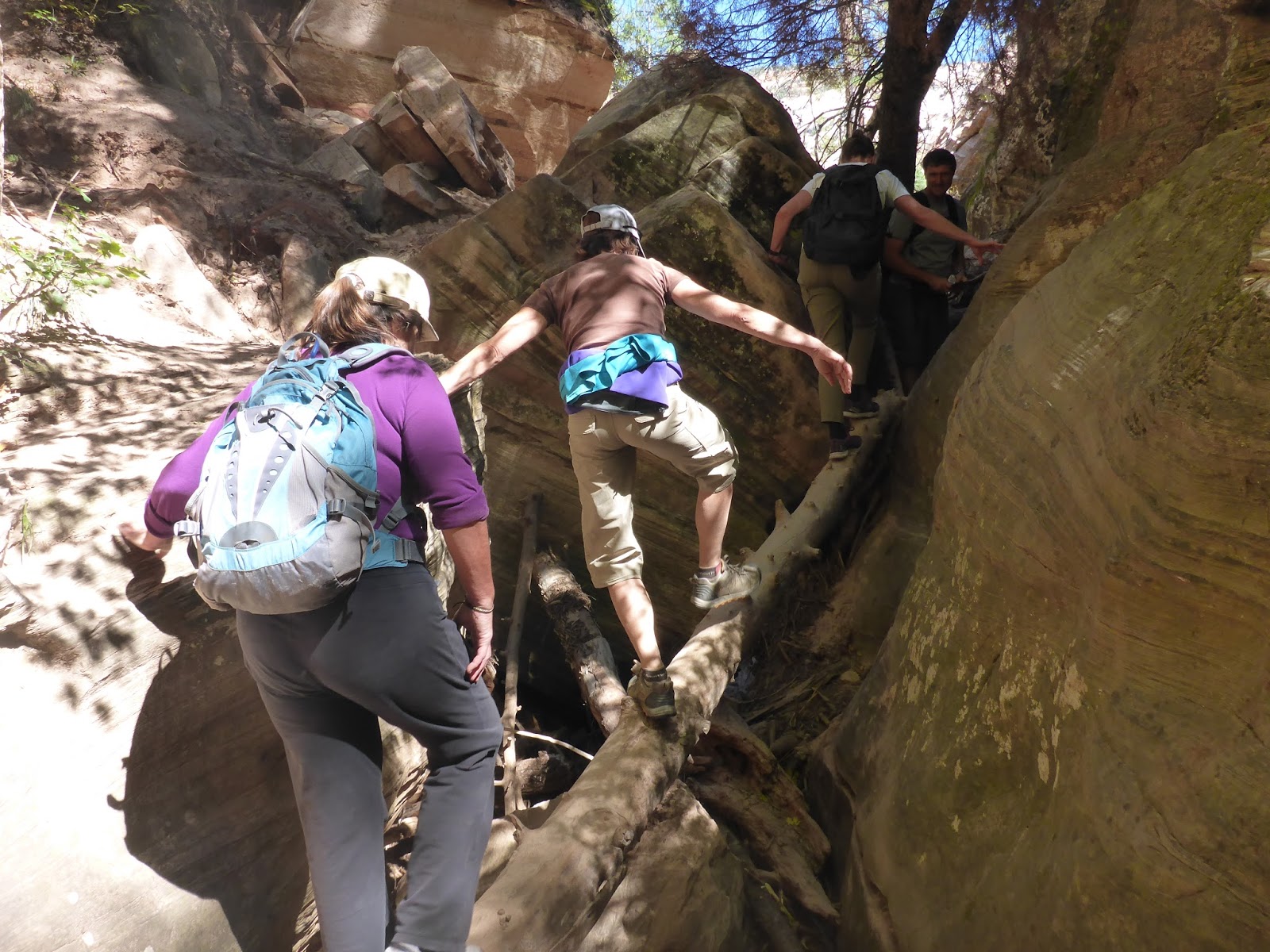
The trail skirts the edge of the cliffs, but there are usually some chain handrails to hold on to when it gets really narrow.
We then entered Hidden Valley itself, a beautiful narrow canyon that required a bit of scrambling to access


A natural ladder


Kaj and Teresa, the inspiration for the trip

Heading back down
After finishing the hike said our goodbyes to Kaj and Teresa, who were going to continue to explore the area for the next few days.  We took the bus back to the car and hit the road for Vegas. We dropped Sandy off and drove a bit further, pulling off the freeway into the Mojave Preserve again.  We didn't go quite so far from the freeway this time, and the World's Tallest Thermometer was visible off in the distance.

We took a brief hike near camp in the morning, visited the incredibly kitschy Alien Jerky store in Baker, and hit the road for home.  As we drove across the desert, we decide to pull out the Mountain Bike Project app and see if there were any good rides along our route home.  We found a couple of prospects in Tehachapi and decided to give one a try.  We found an area with lots of trails, and many more in the process of being built by the local trail association.  Needless to say, in an area with a thousand windmills the wind was blowing briskly.  It gave us a nice boost uphill, and kept us from getting overheated.
Donette rides a new section of flow trail in the foreground, while workers in mammoth machinery toil away at removing a mountain in the background
As we continued our drive home we realized that it was almost exactly 8 years ago to the weekend that we were last in Southern Utah, celebrating Skip's 50th birthday by riding the Whole Enchilada in Moab.  We made a vow to not wait another 8 years to return to this beautiful corner of our world.